Welcome To The Official Website for

AREA D
DISASTER MANAGEMENT

Los Angeles County

MEET THE AREA D COORDINATOR AND LEARN WHAT AREA D DOES FOR YOU

LEARN ABOUT HELPING YOUR COMMUNITY WHEN DISASTER STRIKES

GET THE LATEST NEWS FROM YOUR
AREA D DISASTER MANAGEMENT TEAM

UPDATES

Get the latest updates on local incidents

What We Do

Area D provides disaster management and training for 23 cities within the
East San Gabriel/Pomona Valley of Los Angeles County, California

Area D Platoon

By mutual agreement, the Los Angeles County Sheriff’s Department and the forty-seven (47) local police departments
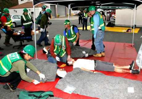
CERT Program

The CERT concept was developed and implemented by the Los Angeles City Fire Department in 1985.

i

Moulage Request Form

Is your city or agency conducting an exercise? Do you have victims that could use some artificial wounds? 

News and Updates

Get the latest Area D news, information, upcoming events, safety tips, and incident updates.

Stay connected with us

Follow Us On Instagram!

Repost from @nwslosangeles

Here`s an update to our current storm. Notice that rainfall and snowfall totals have increased. 0.5-1" of rain across coasts/valleys, and 1-2" across foothills/mountains are expected. Expected snow totals have increased to 4-8" with isolated 14" possible. Additionally, there is a 30% chance of up to 1 inch of snow possible over Tejon Pass/the Grapevine. There is a 20% chance of thunderstorms through Thursday morning. Prepare accordingly, and make sure to take shelter if you hear any thunder.#socal #cawx #LARain #larain #LAsnow #lasnow
...

Repost from @cal_oes

Disaster Recovery Centers are a resource hub for residents and business owners in eligible counties impacted by February and March storms.
...

Repost from @nwslosangeles

Good afternoon from the Day Shift (Rich, Robbie and Kristen)!!!

Well, it looks like a rather cold and windy inside slider will be impacting the area, beginning Sunday night and continuing through Monday. The main concern will be strong west to northwest winds, Wind gusts of 60-75 MPH are expected across the mountains and Antelope Valley with gusts 30-50 MPH across the coasts and valleys. Additionally, there will be strong gale force winds (gusts 35-45 knots) across all the coastal waters on Monday. These strong winds will make for hazardous driving conditions for high profile vehicle as well as hazardous boating conditions for mariners. Also, there could be downed trees and power lines.

As for precipitation chances, like most inside sliders, this system will be moisture starved. Therefore, significant precipitation is not expected (totals, if any, will be less than 0.10 inches). The best chances for any measurable precipitation will be over the mountains. Snow levels will drop to the 2500-3000 foot levels on Monday and Monday night. So, any shower activity that develops could produce some "dicey" wintry driving conditions across the mountains (especially the Tejon Pass through the I-5).

Stay tuned for the latest details on this upcoming system.
...

Repost from @nwslosangeles

This upcoming storm is looking to be generally weaker than past storms of this winter, except for a slight chance of thunderstorms late Wednesday-Thursday ☂️. Prepare for slick roads and travel delays and don`t forget to increase following distance with the car in front of you. #LArain #Socal #cawx #ventura #santabarbara #losangeles #Sanluisobispo
...

Repost from @nwslosangeles

It`s raining, it`s pouring, the old man is 😴💤! Here is our latest forecast for rainfall timing and intensity. This storm brings a slight chance of thunderstorms Wednesday and Thursday. As always, if thunder roars, go indoors! #LARain #larain #sanluisobispo #santabarbara #ventura #losangeles #cawx #socal
...

Late season strong winter storm to impact the region Tuesday into Wednesday with widespread moderate to locally heavy rain and mountain snow. Damaging winds are also possible for many areas.

See the graphic and check out our website: weather.gov/lox for more details!
...

Repost from @nwslosangeles

Good afternoon from the Swing Shift (Rich, Robbie and Kristan)!!!

We are still expecting a significant storm to, once again, impact Southwestern CA. This is our latest thinking about timing and intensity of rainfall for the area. #CAwx
...

Repost from @nwslosangeles

Moderate to brief heavy rain will continue to move over Ventura and Los Angeles Counties through the early evening hours. Minor flooding is likely to occur in urban areas along with small stream flooding. Rainfall rates of 0.30-0.50 inch per hour have been common and isolated thunderstorms could occur.

Move away from streams and drainages that could flood. If you see moving water across a roadway, Turn Around Don’t Drown. Stay tuned to NOAA Weather Radio and/or your favorite media source for updates on this situation.
...

Repost from @nwslosangeles

Good afternoon from the Day Shift (Rich, Ryan, Rose, Lisa and Dave)!!!

Well, we still are on track for a significant atmospheric rain event for our forecast area from later today through early Saturday morning. By far, the heaviest rainfall will occur across San Luis Obispo county, but all areas will receive some decent rainfall.

Current forecast totals are:

- San Luis Obispo county: 2-5" except 5-10" across the NW part of the county.
- Santa Barbara county: 2-4" with local amounts up to 5" in the foothills.
- Ventura/LA counties: 0.75-1.50" with local amounts up to 3" in the foothills.

Significant hydrologic issues are possible across San Luis Obispo and Santa Barbara counties, including flooding of rivers and streams, urban flooding as well as mud and landslides. Therefore, a FLOOD WATCH is in effect for these two counties. For Ventura and LA counties, only minor nuisance type of urban flooding is expected.

Snow levels will remain very high, above 9000 feet, through a majority of this rain event. Significant snow melt is likely below 6000 feet elevation. Above 6000 feet, there will be a significant danger of avalanches as well as the potential for snow sliding off roofs (which can result in injury or death).

Along with the rain, there will be some gusty south to southwest winds across San Luis Obispo and Santa Barbara counties as well as the Antelope Valley. Wind gusts of 35-50 MPH will be likely with the potential for local gusts around 60 MPH.

Stay tuned for the latest details on this storm.
...

Good afternoon #SoCal!!!

Here is a nice one page graphic of the expected rain impacts from our impending storm. #CAwx
...

Repost from @nwslosangeles

Good afternoon from the Day Shift (Rich, Mike and Dave)!!!

Although the storm continues to wind down, there still will be scattered showers and thunderstorms across the area through tonight. Any thunderstorms will be capable of producing small hail/graupel, gusty winds and brief heavy rains. Snow levels will remain very low, generally in the 1500-3000 foot range, through tonight. So, there will continue to be the threat of some snow across the valleys.

After a bit of a reprieve on Sunday, a series of weak storms will impact the area in the Monday through Wednesday time frame. This series of storms will be much weaker than what we have just experienced. However, there will be some decent rain and snow totals with these storms.

Stay tuned for the latest details with this active weather.
...

Repost from @lacoanimals

🥶 Huskies rejoice! But on a serious note, it will be really, really cold this week.

Please make sure you keep your pets safe and limit outdoor time when temperatures are low.
...

Blizzard warning for extremely dangerous mountain conditions coming. Mountain travel will be a mess.

Clarification note on previous post: After review more records, This is the first blizzard warning that we are aware of (even dating back before 2007).
#cawx #larain
#cawx
...

Prolonged VERY COLD and unsettled pattern on track for late Tuesday through possibly next weekend!

Low confidence on storm details given its Alaskan origin and this rare pattern. Widespread significant rain and mountain/high desert snow is possible.

#CAwx #CArain
...

Repost from @nwslosangeles

A weak storm system will bring mainly light rain and low elevation mountain snow to the area late Saturday into early Monday. The heaviest rain will be in Northwestern San Luis Obispo county. A trace of snow could affect Tejon Pass Sunday night through Monday morning, with 1-2 inches of snow possible on the northern slopes of the Ventura Mountains.
...

This error message is only visible to WordPress admins
Error: Access Token is not valid or has expired. Feed will not update.

Supported Cities

Z

Arcadia

Z

Azusa

Z

Baldwin Park

Z

Bradbury

Z

Claremont

Z

Covina

Z

Diamond Bar

Z

Duarte

Z

El Monte

Z

Glendora

Z

Industry

Z

Irwindale

Z

La Puente

Z

La Verne

Z

Monrovia

Z

Pomona

Z

Rosemead

Z

San Dimas

Z

Sierra Madre

Z

South El Monte

Z

Temple City

Z

Walnut

Z

West Covina